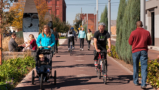
The Community Civic Campus project will add new pathways and an extension of the Centennial Way Trail through the site, connecting to a new signalized trail crossing at Chestnut Avenue, and pedestrian, bicycle, and transit improvements along El Camino Real.
The design team prepared a Conceptual Multimodal Access and Circulation Plan to address travel to, from, and within the Civic Campus site. Planning efforts were built upon an extensive body of work conducted by the City of South San Francisco, including the General Plan, El Camino Real/Chestnut Avenue Area Plan, Bicycle Master Plan, Pedestrian Master Plan, and the Grand Boulevard Initiative project.
The Community Civic Campus’ central location and proximity to the Centennial Way Trail presents a unique opportunity to connect the City’s transportation system and support a vibrant neighborhood. Community and stakeholder feedback provided during the outreach process indicated that El Camino Real and Chestnut Avenue presented barriers to walking and biking to the Community Civic Campus. Moreover, the gap in the Centennial Way Trail along Antoinette Lane and lack of east-west connection between Arroyo Drive and Oak Avenue limits travel to and through the campus area. For these reasons, this project provides not only an opportunity to enhance community services, but to improve transportation and connectivity as well.
There are several transportation projects in progress near the Community Civic Campus site and the design team will implement several other multimodal transportation improvements:
- The City of South San Francisco and Caltrans are implementing the Grand Boulevard Initiative project to reduce pedestrian crossing distances and add a landscaped median along El Camino Real between Arroyo Drive and Chestnut Avenue.
- The SummerHill Apartment Communities (988 El Camino Real) development will add a signalized crossing for the Centennial Way Trail across Chestnut Avenue, straighten the eastern crosswalk at El Camino Real/Chestnut Avenue, and retime the traffic signal at El Camino Real/Chestnut Avenue.
- A separate engineering study is also exploring the feasibility of a future Oak Avenue extension.
- The cross-section of Antoinette Lane will be reduced by ten feet to relocate the Centennial Way Trail on to the project site.
While a majority of users are expected to access the Community Civic Campus via automobiles, above-average use of walking, biking, and transit is expected due to the site’s central location. Approximately 85 percent of non-work trips within the City of South San Francisco occur via automobile, including 45 percent driving and 40 percent carpooling. However, the site’s location is within less than one mile of existing residential and schools, along with planned improvements to pedestrian, bicycle, and transit facilities. This presents an opportunity to support non-auto modes of access. The City will strive for a 75 percent automobile mode share goal through transportation demand management (TDM) measures that encourage carpooling, walking, biking, and transit use.
Parking will be shared between uses and managed during special events. Passenger pick-up and drop-off areas, as well as loading/unloading zones will be provided. The Community Civic Campus will also include bicycle parking spaces.
Emergency vehicle access will be prioritized through various traffic control design features and treatments.
